Instant Landscape for

Unreal Engine logo

Introduction to Wysilab's new project

Wysilab’s new ambition is to create a tool to work extremely simply in 3D on existing landscapes and automatically improve even more the quality for a very high-quality rendering for a precise and ultra-realistic result.
With live-link, the user can directly use the result in Unreal Engine and all the necessary data.

Instant Landscape is the current working name of this tool.

Changing low quality data into a very-high quality rendering

Today, you can download any part of the world (digital elevation model + satellite map), transform it into terrain, and export it to Unreal Engine.
For example, Instant Terra, through its World browser functionality and its Unreal Engine plugin, can download any part of the world with a resolution of up to one meter, and send it to Unreal Engine in one click.

This quality is sufficient for a view from a distance, but completely insufficient for a close-up view.
To increase the quality, materials and vegetation must be added and the 3D scene reworked. This work can take several days to several weeks, depending on the size of the terrain and the expected quality.

Close up view with low quality
The first objective of the Instant Landscape project is to allow users to download any part of the world (in low quality), then to fully and automatically generate all the necessary data (materials, material or mask layers, vegetation, masks for vegetation, etc.) to transform this low-quality scene into an ultra-high-quality scene, directly usable, including for close-up views. Starting from the geographic location, the altitude, and the current satellite image, a complete landscape is generated with detailed and consistent vegetation, including trees, grass, rocks, any relevant material, for final, hyper-realistic rendering, even in a close-up view in Unreal Engine.
High-quality rendering with Instant Landscape
Automatic high-quality rendering with Instant Landscape
This scene does not correspond exactly to reality, but all data created are plausible, and from a user’s perspective, exactly matches the uploaded area. All data are transferred automatically (live-link) into Unreal Engine.

Easy changes on the landscape, control and consistency

The second objective of the Instant Landscape project is to make it very easy for users to modify an existing scene, while maintaining ultra-high quality. Examples of modifications include replacing one biome with another (adding or removing grass, snow, water, replacing wet soil with arid soil, replacing one type of vegetation or forest with another, etc.) and modifying mountain ranges, rivers, etc.
Initial biome
Initial biome
Updated biome
Updated biome
The quality obtained, in particular at the level of the transition between the different zones, will be a determining criterion for the success of the project.

Ultra-realistic 3D landscape from real data or a custom terrain

From any region directly downloaded in Instant Landscape, or from any custom terrain, you modify the topography and compose the final landscape from realistic biomes.
Instant Landscape can create any realistic landscape by composing different biomes defined as a set of reliefs, vegetation, and rules. For example, you can position an alpine chain of mountains with plains and they will automatically be populated with the relevant vegetation and textures.

User control is the key: any automatic biome used in your landscape can be tuned to fit your expectation. You can also create your own biomes.

Data shared with Unreal Engine will include the heightmap, the textures, the 3D objects (vegetation…) and their location.

Digital twins for natural environments for Unreal Engine

“Digital twins” often refers to urban environments, such as cities, traffic maps, factories, buildings, machine tools, etc. More and more tools manage these assets efficiently; however, the natural environment is much less represented because of the technical challenges of managing large dimensions: the user is quickly confronted with the issue of managing tens or hundreds of square kilometers with the volume of data that it entails.

Instant Landscape is designed to meet this need. You can retrieve an existing location (natural park, quarry, coast, golf courses, flood zones, seismic zones, intervention zones, etc.) for a closer representation, and if necessary, simulate changes in its relief or appearance.
Instant Landscape makes this possible, simply and intuitively, and for everyone.

An easy-to-use tool for all fields handling virtual landscapes

Instant Landscape is designed so that it can be used by as many user profiles as possible, even the less technical ones in fields as varied as architecture, town planning, automobile simulations (autonomous cars), military simulations, aeronautics, advertising, or documentaries including simulations. It will also be of interest in the field of video games for which the requirement of realism is increasingly important.

Technical corner

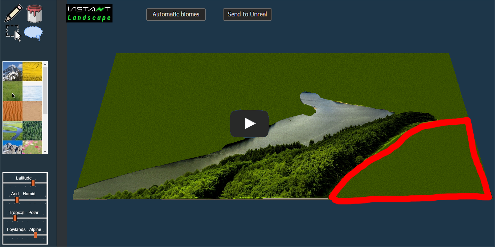
The project will require the creation of a biome and sub-biome system.
A biome corresponds to a type of landscape, for example, an alpine mountain, a desert, meadows, etc.
A biome is built from a series of sub-biomes. A sub-biome corresponds to a single element of a landscape, for example, a forest, undergrowth, a path, etc.
A sub-biome contains, in particular:

  • One or more terrain models
  • One or more materials
  • Masks used by materials and/or rules to generate these masks
  • Vegetation
  • Masks used to apply vegetation and/or rules to generate these masks.

Several biomes will be predefined and directly usable.
Users can create biomes, the results of which can be directly used in Unreal Engine.

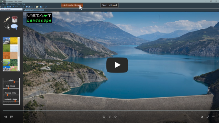
Based on the technological achievements of Instant Terra, Wysilab’s first software dedicated to the creation of 3D terrain, Instant Landscape benefits from Wysilab’s five years of R&D to offer unparalleled performance in the management of large dimensions and hyper-realism through a simple, fluid workflow for incomparable results.

Instant Landscape will use the live-link system already used by Instant Terra Unreal Engine plugin to send all data, including materials, vegetation and biomes, to Unreal Editor in just one click.

Project planning

Total duration

The project is planned for a period of 15 months. The workload represents 60 man-months.

The team involved in the project

Here is the composition of the target team for the project and the distribution of the workload.

The different steps

STEP 1

 PBR material support

  • Compatibility with Unreal Engine materials
  • One-click export to Unreal Engine (live-link)
STEP 2

Vegetation support

  • Compatibility with the Unreal Engine foliage system
  • One-click export to Unreal Engine (live-link)
STEP 3

Improved rendering

This part covers the shading system, the sky display, and other graphical improvements.
STEP 4

Establishment of the biome and sub-biome system

A biome corresponds to a type of landscape, for example, an alpine mountain, a desert, meadows, etc. A biome is built from a series of sub-biomes. A sub-biome corresponds to a single element of a landscape, for example, a forest, undergrowth, a path, etc.

A sub-biome contains, in particular:

  • One or more terrain models
  • One or more materials
  • Masks used by materials and/or rules to generate these masks
  • Vegetation
  • Masks used to apply vegetation and/or rules to generate these masks.

Several biomes will be predefined and directly usable.
Users can create biomes, the results of which can be directly used in Unreal Engine.
The definition of biomes and sub-biomes can be refined as needed during the constitution of a biome bank (see next step).

STEP 5

Creation of a biome and sub-biome bank

This is a major step in the production of graphical data. It allows:

  • Validation of the previous step of setting up the biome and sub-biome system;
  • Work on the rules for mixing biomes and sub-biomes (see next step).
STEP 6

Algorithms for mixing biomes and sub-biomes

This step will start as soon as a sufficient number of biomes and sub-biomes are produced.
Deep-learning algorithms can be used to determine the best rules for mixing automatically or semi-automatically (very simple user guidance to gain control over the process) of biomes and sub-biomes.

STEP 7

Biome painting and sculpting tools

This step allows users to edit extremely simply (magic wand, pipette, brushes) the different biomes of a terrain.
Depending on the constraints, editing can be done directly in the Unreal editor or the results can be available in one click (live link).

STEP 8

Automatic detection of biomes and sub-biomes from real data

When the user downloads real data (heightmap and satellite image), the resolution is of the order of a few meters, at best a meter or a fraction of a meter. This is sufficient for far vision, but unusable when approaching.

The objective of this major part is to determine likely biomes and sub-biomes for all parts of the downloaded terrain.
Suitable terrains, masks, materials, and vegetation are used to transform the low-quality scene into a very high-quality scene (see the next step). This scene does not correspond exactly to reality, but all data created are plausible, and from a user’s perspective, exactly matches the uploaded area.
This step involves intensively AI and deep learning.

STEP 9

Automatic quality improvement

This step is an extension of the previous one: once the biomes and sub-biomes have been selected, the corresponding data must be generated to obtain a very high-quality scene.
This step is very iterative with most certainly many rules to manage.

STEP 10

Tools to improve data while maintaining quality

Once a high-quality scene has been generated, the final step is to offer tools to the user to modify this scene (interchange biomes, modify the relief, etc.), while maintaining the same quality.

-->