Wysilab has released Instant Terra v1.3. Import meshes, browse your nodes and resources in the Graph explorer, rock and hydraulic improved erosion, and more.

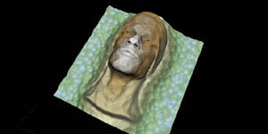
Import terrain from mesh

This node creates a terrain from an 3D mesh file. The mesh is transformed into a heightmap by computing a depth projection according to a viewing vector.

Interface improvements: Graph explorer and Models window

The Graph explorer is where you manage all the nodes and resources used in a project. It lists the various types of nodes as displayed in the Graph editor and updates in real time when you edit a node.

The Models window displays a list of all the nodes that you can use in a project. You can sort the nodes by category or alphabetically, search them, and drag and drop them into the Graph editor.

Improved erosion

We have improved the rock and hydraulic erosion nodes so users can access all the options they need through a series of sliders.

Ultra-fast import process

Import your different files in one shot. Even with GBs of input data you start working very quickly on your project.

The example below is an import of 16GB. Without accelerated import, it takes more than 3 minutes before you can start working on your project. With accelerated import, it takes just 6 seconds.

API for integration in your pipeline

Use the simple, but complete Python API to automate the calculations and integrate Instant Terra PRO into your pipeline. Enterprise edition only. Not available in the trial edition. Contact us for a demo.

What’s next?

Components: We’re finalising the components feature that provide a powerful way to create new nodes to use in the graph. Components group component instance nodes, each with their own parameters.

Multi-scale erosion: We’re in the R&D phase of multi-scale erosion. An enormous potential with this feature! Watch this space….